Today’s guest blogger is Patrick Ross.
Over the past few years, Patrick has worked with the Duke Lemur Center in North Carolina, the Lemur Conservation Foundation in Anjanaharibe Sud Special Reserve in Madagascar, and the Mad Dog Initiative. In this blog post, he will share his experiences in Madagascar and what he hopes for the future.
Tell us about your background in lemur research.
I am a senior undergraduate student in Sustainable Development from Appalachian State University, graduating in December 2019. I first got interested in conserving Madagascar’s rainforests through working on breaks from school at the Duke Lemur Center.
You recently returned from Anjanaharibe Sud Special Reserve in northeast Madagascar. Can you tell us more about this reserve?
Anjanaharibe Sud Special Reserve is an incredible place. It is lush, with life booming all around. Thought of as one of the most biodiverse places on the island, it is home to many animals that are found nowhere else on earth.
Maybe its most unique physical quality however is the rapid elevation change that can be found within the park. Some of our transects could change elevation by 1,000 m in just a couple of kilometers!
» Learn more about the Anjanaharibe Sud Special Reserve
Tell us about the work you were doing in ASSR.
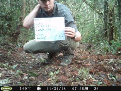
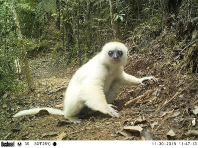
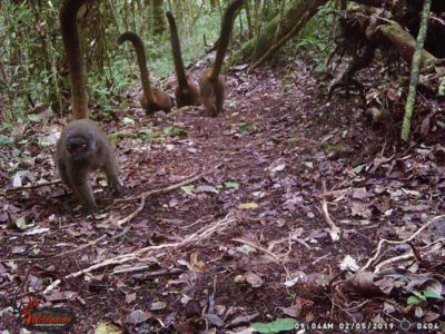
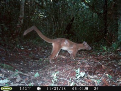
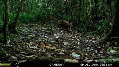
We sought to prove which ground traversing animals exist within the forest. We were primarily focused on carnivores, but have captured many pictures of small herbivores such as birds and tenrecs. To do this, I set up 35 motion activated trail cameras across the forest floor. These cameras took pictures of everything that came in front of them.
Who did you work with during your research?
My work was only made possible by an extraordinary team of people. My project was done with the instruction, coordination, and help of the Lemur Conservation Foundation.
The following individuals were instrumental in the success of this rigorous research project:
- Louis Joxe Jaofeno (LCF Madagascar Program Manager),
- Guy Irenel Raoloniaina (Madagascar National Park Guide, Research Assistant),
- Rojo Nandrianina Ravelojaona (University of Antananarivo student), and
- Jao Jean Theodore (Local ASSR Guide / CLP).
What do you envision for the future of this region of Madagascar, and for Madagascar as a whole?
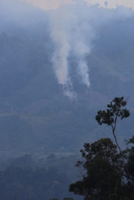
To be honest the future is bleak. I think the current stat is that 67,000 acres of rainforest are killed each day. If we do not want some of the last remaining bastions of biodiversity on Madagascar to face this same fate, it will be on us to work as hard as we can to ensure that some of these places remain.
But, so many of the destructive forces that work against these places are fixable.
Madagascar can be quite an adventure. Was there a time during your time in Madagascar that was particularly funny or adventurous?
I felt a pressure to conduct myself in a manner that represented Americans well. This was to my downfall in one instance as I got completely covered with mud while helping to push a local tractor and trailer through a particularly muddy section of road.
We were walking along a rural road on our way back from the last transects of the day when we came across 7 people trying to push a tractor pulling a trailer up a muddy slick hill. I asked my team if we could help they agreed and we were all dirty by the end as the tractor flung mud while trying to crawl up the hill!
Summer Update from Patrick Ross
I am very lucky to be back in Madagascar this summer, as we speak! This time, I am working with the Mad Dog Initiative, under Dr. Zachary Farris and Dr. Kim Valenta. My camera trapping and conservation-focused forest ecology and assessment work continues.
I am also lucky enough to get a chance to diversify the kind of data I work with, and will be piloting a drone above the forests adjacent to Andasibe: VOI, MITSINJO, and Mantandia. There’s a cool and relatively new process that allows researchers to make hyper-detailed 3D models of forest or landscape with the use of aerial photography I.E drones. With these video and/or models, we will be able to accurately assess canopy specifics such as height, width, species type, and condition.
Hopefully, both my continued camera trapping and this new view from the drone will provide an opportunity for even better management, understanding, and preservation of the forest.